


beris Pré Balthazar retour

filly
Gebruiker

Lengte
11,5 km

Max. hoogte
450 m

Positief hoogteverschil
238 m
Km-Effort
14,9 km

Min. hoogte
251 m

Negatief hoogteverschil
310 m
Boucle
Neen
Datum van aanmaak :
2021-01-05 09:05:48.797
Laatste wijziging :
2021-01-05 11:11:52.727
2h05
Moeilijkheid : Gemakkelijk

Gratisgps-wandelapplicatie
 SityTrail
IGN / Geografische instituten
SityTrail Plus
De wereld gaat voor u open
Over ons
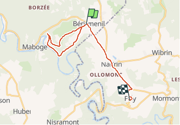
Tocht Stappen van 11,5 km beschikbaar op Wallonië, Luxemburg, La Roche-en-Ardenne. Deze tocht wordt voorgesteld door filly.
Beschrijving
descente vers l ourthe et remontée Berismenil
Plaatsbepaling
Land:
Belgium
Regio :
Wallonië
Departement/Provincie :
Luxemburg
Gemeente :
La Roche-en-Ardenne
Locatie:
Samrée
Vertrek:(Dec)
Vertrek:(UTM)
690175 ; 5561846 (31U) N.
Opmerkingen